Cuyahoga Valley National Park: Complete Trail Guide
Brecksville–Northfield High Level Bridge

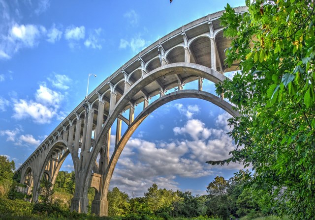

The massive concrete arch bridge crossing the valley carries Route 82 through the park, soaring 145–175 feet above the river. Built in 1931 with reinforced concrete, it stretches over 1,100 feet in length. Its towering arches and vertical supports span the entire Cuyahoga River valley, creating a dramatic sight—especially from below near the river and trails. One of the park’s most iconic landmarks, it’s best viewed from the Station Road Bridge area in Brecksville, where you can look up from the valley and take in the river, the old iron bridge, and this giant structure all in one breathtaking scene.
🏔 125+ miles of trails • 33,000 acres • No entrance fee
📍 Between Cleveland & Akron • Open year-round
🥾 Brandywine Gorge (1.4 mi) • Ledges Trail (2.2 mi) • Blue Hen Falls (3 mi) • Towpath Trail (19.5 mi)
Ohio has one national park. Just one. And honestly, Cuyahoga Valley National Park punches so far above its weight that the state doesn't need a second.
Tucked between Cleveland and Akron in northeast Ohio, this 33,000-acre stretch of forested gorges, sandstone ledges, and river valley trails draws nearly three million visitors a year. That makes it the twelfth most-visited national park in the country — ahead of Glacier, ahead of Grand Teton, ahead of parks most people would consider far more "dramatic." The thing is, Cuyahoga Valley doesn't need dramatic. It earns you with subtlety: the drip of Brandywine Falls echoing off a gorge wall, the cool breath of air rolling out of Ice Box Cave, the way October light filters through 320-million-year-old rock formations at the Ledges.
Best of all, there's no entrance fee. You can drive in, park, and start hiking without pulling out a wallet.
This guide covers the four trails you should absolutely prioritize on a first visit — or a fifth — plus the history, geology, seasonal tips, and practical logistics you need to plan a solid day in the park.
Getting There
Cuyahoga Valley stretches roughly 20 miles north to south along the Cuyahoga River, with access points scattered all along that corridor. The main visitor center is at Boston Mill, located off Riverview Road near the town of Peninsula.
Boston Mill Visitor Center
6947 Riverview Road, Peninsula, OH 44264
Coordinates: 41.2563, -81.5578
From Cleveland, take I-77 South to Route 21, then follow signs to Riverview Road. The drive is about 25 minutes from downtown. From Akron, head north on Route 8 to Route 303 West, then turn north on Riverview Road — roughly 20 minutes.
Parking is free at all trailheads, but Brandywine Falls and the Ledges fill up fast on weekends, especially during fall foliage season. Plan to arrive before 10 a.m. on Saturdays in October, or you'll be circling. Weekday mornings are golden — half the crowds, twice the parking.
Other key parking areas:
- Brandywine Falls Trailhead: 8176 Brandywine Road, Sagamore Hills (41.2744, -81.5376)
- Ledges Trailhead: 701 Truxell Road, Peninsula (41.2268, -81.5575)
- Blue Hen Falls / Buckeye Trail: Park at Boston Mill Visitor Center and hike in
- Towpath Trail (multiple access points): Lock 29 Trailhead in Peninsula is the most popular
The park is open every day, all year, with no gate hours. Visitor centers keep seasonal hours — check the NPS website before you go if you want a map or a ranger chat.
Brandywine Gorge Trail
If you only hike one trail in Cuyahoga Valley, this is probably the one.
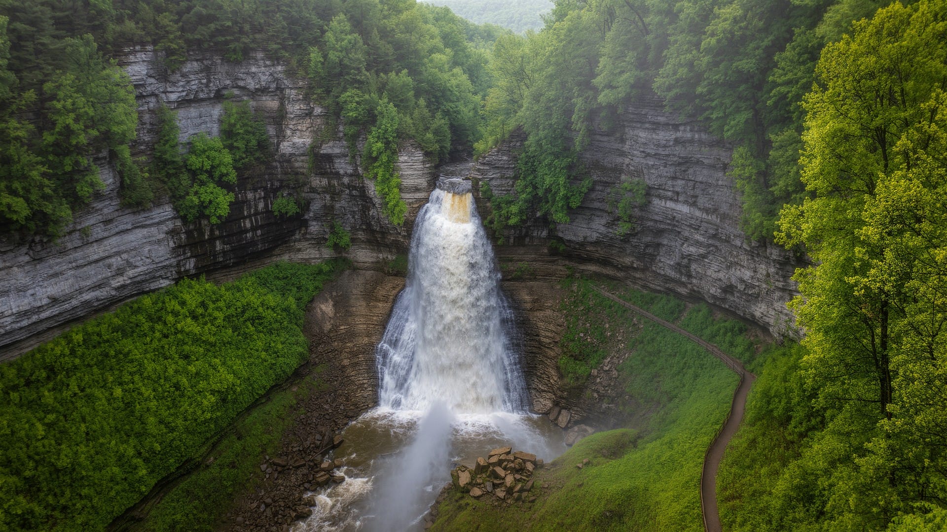
Brandywine Gorge Trail is a 1.4-mile loop with about 160 feet of elevation change. The star attraction is Brandywine Falls, a 65-foot waterfall that drops over a ledge of Berea Sandstone into a gorge lined with Bedford Shale. You can see the falls from a wheelchair-accessible boardwalk overlook right near the parking lot — a short walk from the car, no scrambling required.
But don't stop at the overlook. The full loop takes you down a wooden staircase into the gorge itself, where the sound of falling water amplifies against the rock walls. The trail wraps along the creek at the base of the falls, crosses a footbridge, and climbs back up the opposite ridge through mixed hardwood forest. Plan about 45 minutes to an hour for the full loop, longer if you're stopping for photos.
You will be stopping for photos.
The terrain is moderate. Rocky in places, with some uneven steps, so wear proper trail shoes rather than sneakers. After a rain, the wooden stairs can be slick, but the payoff is that the falls hit their absolute peak flow after a good soaking. Spring snowmelt and April showers turn Brandywine into a full-on torrent.
One detail most visitors miss: look for the orange iron staining on the rocks near the base of the falls. Iron-bearing springs seep through the Bedford Shale and leave those rusty streaks, creating a color contrast against the dark rock that's genuinely striking. It's not something you'll see from the upper boardwalk — you have to take the full loop to catch it.
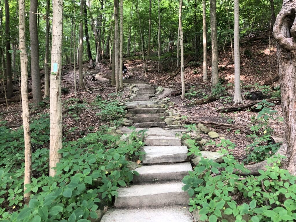
Ledges Trail
The Ledges Trail is where the park stops being "nice" and starts being weird. In the best possible way.
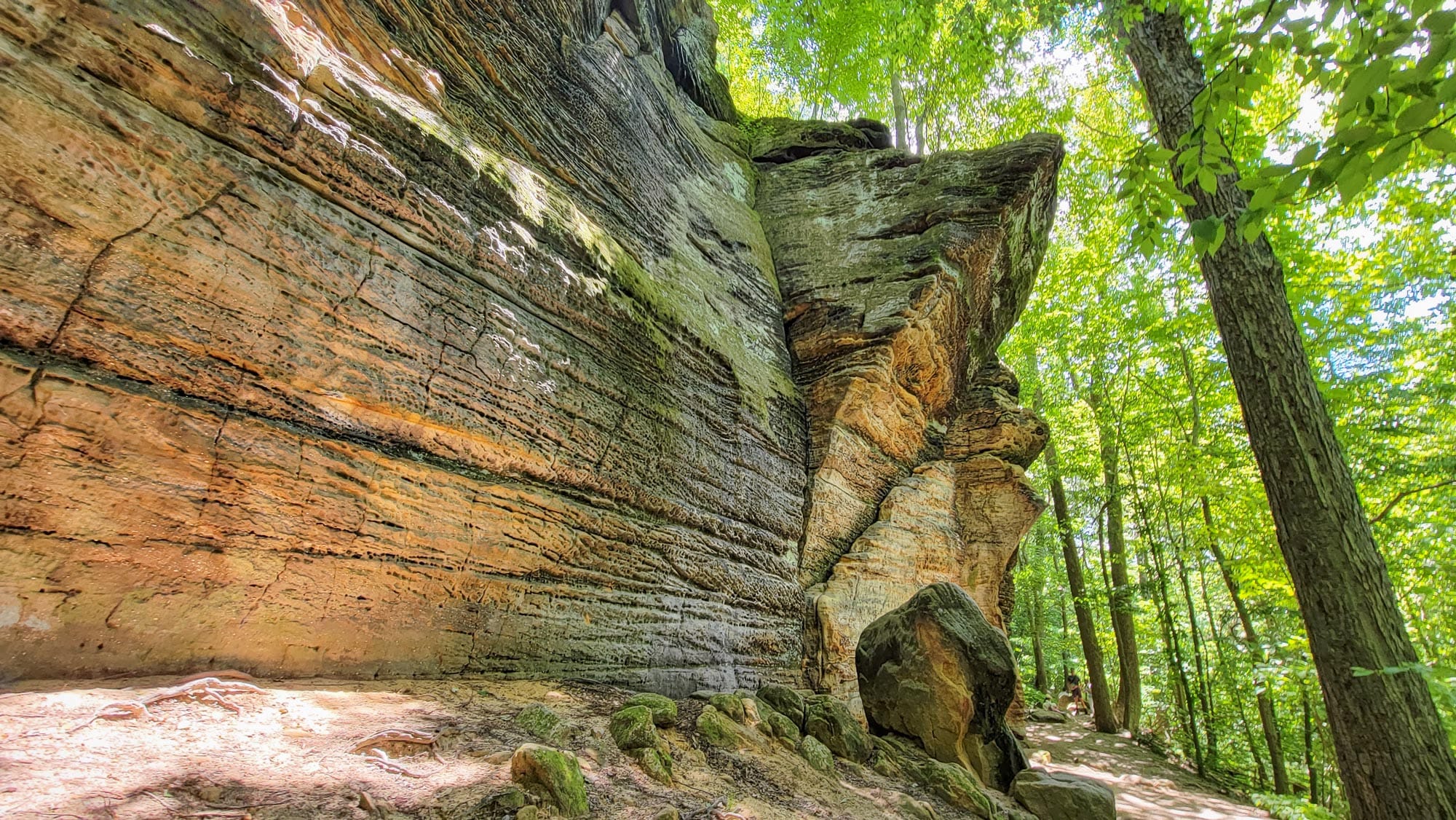
This 2.2-mile loop sits in the Virginia Kendall unit of the park, about a 10-minute drive south of the Boston Mill Visitor Center. The elevation change is only 80 feet, but that number is deceptive — the trail threads between towering walls of Sharon Conglomerate, a 320-million-year-old rock formation packed with white quartz pebbles and riddled with cross-bedding patterns that mark ancient sand dunes.
You'll pass through narrow slots between rock walls, duck under overhangs, and squeeze past boulders that look like they were placed by a sculptor. The most dramatic section is the ledge corridor itself, where joints in the rock have widened over millennia into passages just wide enough to walk through single file. Look closely at the rock faces and you'll spot honeycomb weathering — hollowed-out pits that look like someone took an ice cream scoop to the sandstone. Wind, water, and freeze-thaw cycles do that over thousands of years.
About halfway through the loop, watch for Ice Box Cave. It's not a deep cave — more of a recessed overhang that extends about 50 feet into the rock — but even in July, cold air pools inside and the temperature drops noticeably. On a humid summer day, the contrast hits you like opening a refrigerator door.
The trail ends (or begins, depending on your direction) at Ledges Overlook, a flat rock platform perched above the Cuyahoga Valley. On a clear day, you can see forested ridgeline stretching to the horizon. During fall foliage, this is the best overlook in northeast Ohio. Not "one of the best." The best. Arrive early — it gets crowded.
The Ledges Trail is rated moderate, mostly because of the rocky footing and some stone steps. It's not accessible for wheelchairs or strollers. Dogs are allowed but keep them leashed — the narrow rock passages make passing difficult.
Plan about an hour to 90 minutes, depending on how many times you stop to gawk at the rock formations. Budget extra time in autumn.
Blue Hen Falls via Buckeye Trail
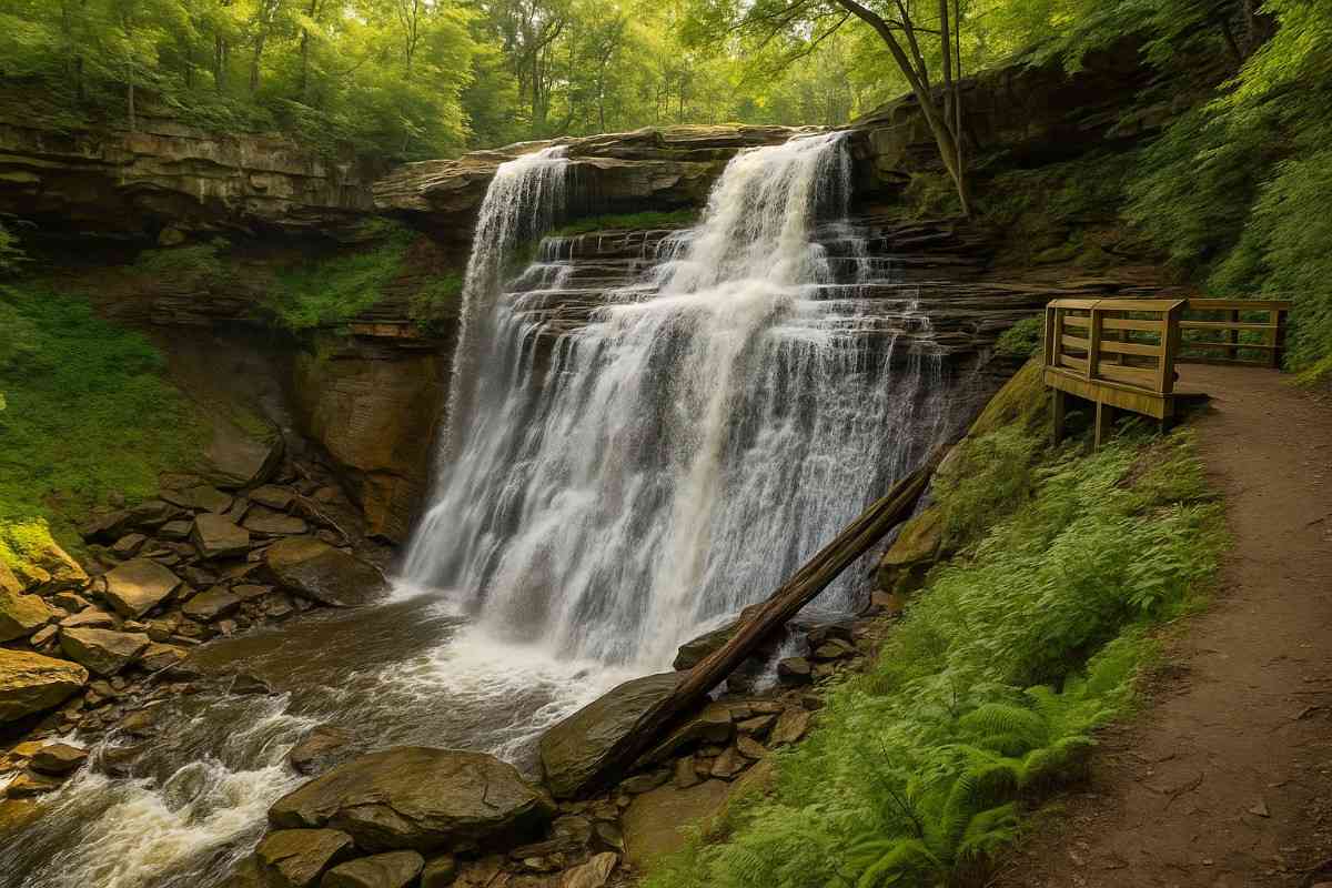
Blue Hen Falls doesn't have the stature of Brandywine, and that's part of the appeal. This 15-foot cascade tucked into a narrow ravine sees a fraction of the foot traffic, and the hike to reach it has a rugged, backcountry feel that sets it apart from the park's more groomed paths.
The route follows the Buckeye Trail — Ohio's statewide long-distance trail, marked with blue blazes painted on trees. From the Boston Mill Visitor Center, the round trip is about 3 miles with 580 feet of total elevation change. That's a real workout by Ohio standards. The trail climbs immediately from the trailhead, cresting a ridge before dropping steeply down a long staircase of stone steps into the ravine where the falls sit.
This is not a paved nature walk. The Buckeye Trail through this section is rooty, rocky, and after rain, genuinely muddy. Good hiking boots are non-negotiable here. Trekking poles help on the descents, especially if the ground is wet.
The falls themselves are quiet and intimate. Water slides over a shelf of rock into a shallow pool surrounded by moss-covered boulders and hemlock trees. In spring, the flow picks up and the ravine fills with the sound of rushing water. In winter, the falls sometimes freeze into a blue-white curtain of ice — one of the most photogenic sights in the park, if you're willing to earn it.
To get there: park at Boston Mill Visitor Center, walk to the intersection of Riverview and Boston Mills roads, cross Riverview Road carefully, and find the stone staircase that marks the Buckeye Trail entrance. Follow the blue blazes. Plan about 90 minutes to two hours for the round trip.
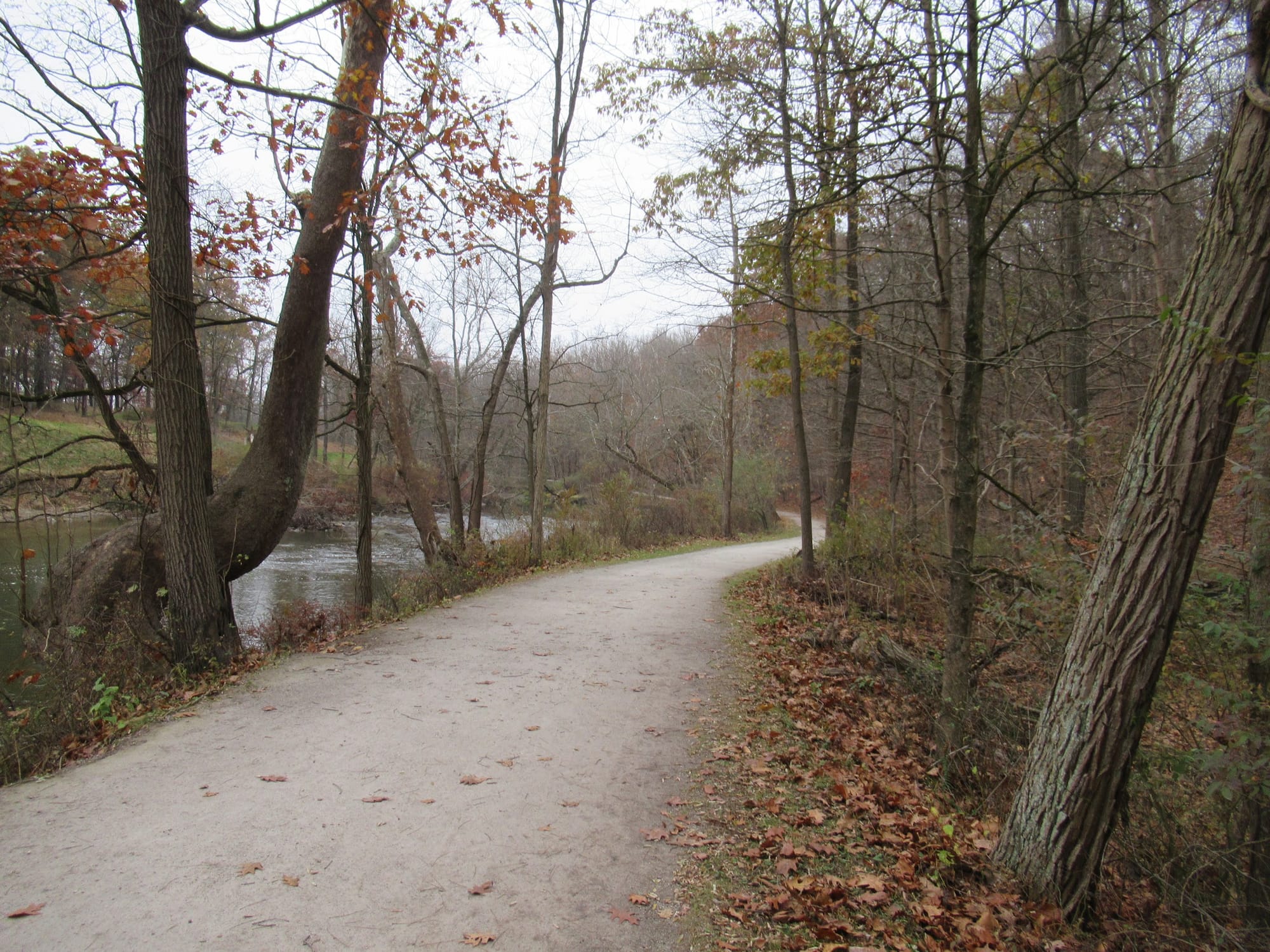
Ohio & Erie Canal Towpath Trail
The Towpath Trail is the backbone of Cuyahoga Valley — a 19.5-mile crushed limestone path that follows the route of the old Ohio & Erie Canal from Canal Road in Cleveland south through the park to Akron.
This trail is flat. Almost perfectly flat. The total elevation change across the entire 19.5 miles is 135 feet, and the surface is firm, even, and wide enough for side-by-side walking. Wheelchairs, strollers, bikes, joggers, dog walkers — everyone shares the Towpath, and it works because there's room for all of them.
You don't need to hike the whole thing. The most popular section runs through the heart of the park between Lock 29 in Peninsula and the Boston Store area, a stretch of about 4 miles that passes restored canal locks, wetland overlooks, and patches of old-growth forest. The Cuyahoga River runs parallel for much of the route, and great blue herons are a common sight along the banks.
Ten trailheads provide access along the full length, so you can tailor the distance to your energy level. Park at one end, hike or bike to the other, and take the Cuyahoga Valley Scenic Railroad back to your car — the train runs parallel to the trail and offers bike-on service during warmer months. It's one of the most cleverly designed trail-and-transit setups in any national park.
For a short walk, the 2-mile stretch from Lock 29 south to the Stumpy Basin area is quiet, scenic, and puts you in the middle of some prime bird habitat. Bring binoculars if you've got them.
Park History and the Stories Written in Stone
Cuyahoga Valley wasn't always a national park. Congress designated it a National Recreation Area in 1974, and it took another 26 years of advocacy before it was redesignated as a full national park in 2000.
But the human history here goes back far further than that. The Hopewell Culture inhabited this valley by around 200 AD, constructing burial mounds including the Everett Mound near the small village of Everett inside the park. Before European contact, the Wyandot, Iroquois, Ottawa, Ojibwe, Shawnee, and other nations lived in and traveled through the valley.
The 19th century reshaped the landscape. The Ohio & Erie Canal, completed in 1832, turned the Cuyahoga Valley into a commercial highway connecting Lake Erie to the Ohio River. The Towpath Trail follows the exact route that mule drivers walked while towing canal boats. When the canal era ended, railroads took over — the same rail corridor now carries the Cuyahoga Valley Scenic Railroad.
The geology, though, makes the human timescale look like a footnote.
The oldest exposed rocks in the park are 400 million years old. The Ohio Shale at the bottom of the sequence formed in an ancient oxygen-poor ocean, and it's packed with fossils of creatures that haven't existed for hundreds of millions of years — including Dunkleosteus, a 40-foot armored predatory fish that was the apex predator of its era. You won't find one sticking out of a cliff face, but knowing what's embedded in the rock beneath your boots adds a layer to the experience.
Above the Ohio Shale sits the Bedford Shale, then the Berea Sandstone that caps Brandywine Falls. Higher still, the Sharon Conglomerate — 320 million years old, full of white quartz pebbles from ancient rivers — forms the massive ledge formations on the Ledges Trail.
Then the glaciers arrived. Between 70,000 and 14,000 years ago, ice sheets advanced and retreated across northern Ohio, carving the valley deeper, depositing boulders carried hundreds of miles from Canada, and leaving behind the rolling moraines and kame terraces visible throughout the park. The Cuyahoga River found its current winding course about 10,000 years ago, after the last glacier retreated.
Walk the Ledges Trail and you're walking through 320 million years of geological history. That's not marketing language. That's the actual timeline underneath your feet.
Tips and Seasonal Notes
Spring (March through May): Wildflowers bloom along most trails starting in April. Herons return to the Bath Road Heronry — March and April are prime nesting season. Waterfalls hit peak flow from snowmelt and spring rain. The tradeoff: trails are muddy, especially Blue Hen Falls. Wear waterproof boots and bring trekking poles.
Summer (June through August): Hot. Humid. Crowded. Go early or go late — before 9 a.m. or after 5 p.m. — and you'll be fine. The Towpath Trail offers decent shade, and the Blue Hen Falls ravine stays cool even on the worst days.
Fall (September through October): This is the season. Temperatures settle into that perfect hiking window — cool mornings, warm afternoons, no humidity trying to suffocate you on the climbs. The foliage peaks around mid-October, and when it peaks, the Ledges Overlook turns into the kind of view that makes people pull out their phones and just stand there for ten minutes. Get to the park before 9 a.m. on October weekends. Seriously. The Ledges parking lot will be full by 10, and Brandywine isn't far behind. Weekday visits in October are the real cheat code.
Winter (November through February): Cuyahoga Valley averages 61 inches of snow annually — substantially more than most of Ohio, thanks to lake effect from Lake Erie. Brandywine Falls and Blue Hen Falls can freeze into ice sculptures. Snowshoeing is permitted on most trails except the Ledges and Brandywine Falls trail systems. Dress in layers and watch for icy boardwalks.
Year-round tips:
- Bring water. Even on cool days, the elevation changes will dehydrate you faster than you expect.
- Cell service is spotty throughout much of the park. Download a trail map before you arrive.
- Restrooms are available at most major trailheads and visitor centers.
- Dogs are welcome on all trails but must be leashed (six-foot maximum). Clean up after them — rangers do enforce this.
- The Cuyahoga Valley Scenic Railroad offers a unique way to explore the park without driving between trailheads. Check their schedule at cvsr.org.
Nearby Trails Worth Exploring
If the Ledges Trail lit something in you — that urge to squeeze between rock walls and peer into dark crevices — northeast Ohio has more of that energy to offer.
Nelson Kennedy Ledges State Park is 40 minutes east and will scratch exactly that itch. Tighter passages, more scrambling, and a couple of caves that actually require you to duck. It's the Ledges Trail's wilder cousin.
For more Cleveland-area options beyond the park, our Best Hikes Near Cleveland guide covers ten more trails including gorge hikes and Lake Erie shoreline walks.
Loved the waterfalls? Our Ohio Waterfall Hikes guide rounds up seven more cascades across the state — including Cedar Falls in Hocking Hills, which makes Brandywine look restrained.
For fall planning, Best Fall Hikes in Ohio covers the top trails statewide for peak color. And for the eternal debate between Ohio's two heavyweights, the Nelson-Kennedy Ledges vs. Hocking Hills vs. Little Rocky Hollow comparison breaks it all down.
Did you know that the Cuyahoga River caught on fire?
The Cuyahoga River, which flows through the national park, was once heavily polluted. For decades, from the 1800s to the 1960s, factories dumped oil, chemicals, and sewage into its waters. In some areas near Cleveland, the surface was literally covered with flammable industrial waste. On June 22, 1969, oil-soaked debris floating on the river caught fire—likely sparked by a passing train. The blaze lasted only about 30 minutes but became internationally famous.

It wasn’t just a single fire, which surprises many people. The river had actually , caught fire multiple times before—at least a dozen since the 1800s. Locals were used to it, so it didn’t seem remarkable until it made national headlines. The “river on fire” tale remains one of the most iconic stories of environmental recovery in the U.S.
Even though the fire was small, it became a powerful symbol of environmental neglect. It helped ignite the modern environmental movement and contributed to the creation of the EPA and the passage of the Clean Water Act in 1972. It was a wake-up call to the country that our rivers were in seriously bad shape.
The river winds through roughly 25 miles of Cuyahoga Valley National Park, and today it’s a completely different scene—teeming with fish, birds, and even bald eagles. Over 40 species of fish now thrive here, and the river has become a favorite spot for kayaking, scenic hikes, and all sorts of outdoor adventures.
Conclusion
The Cuyahoga Valley National Park offers wonderful trails to explore. I really enjoyed visiting it. I highly recommend that you visit the only national park in Ohio.