Columbus Metro Parks: Franklin County Trail Guide 2026
Trail Map
Interactive map showing the trail route for Columbus Metro Parks: Franklin County Trail Guide 2026. The map displays topographic information and trail markers.
Elevation Profile
Elevation data not available for this trail.
Chart showing elevation changes along the trail distance. Hover or focus on the chart to see specific elevation values at each point.
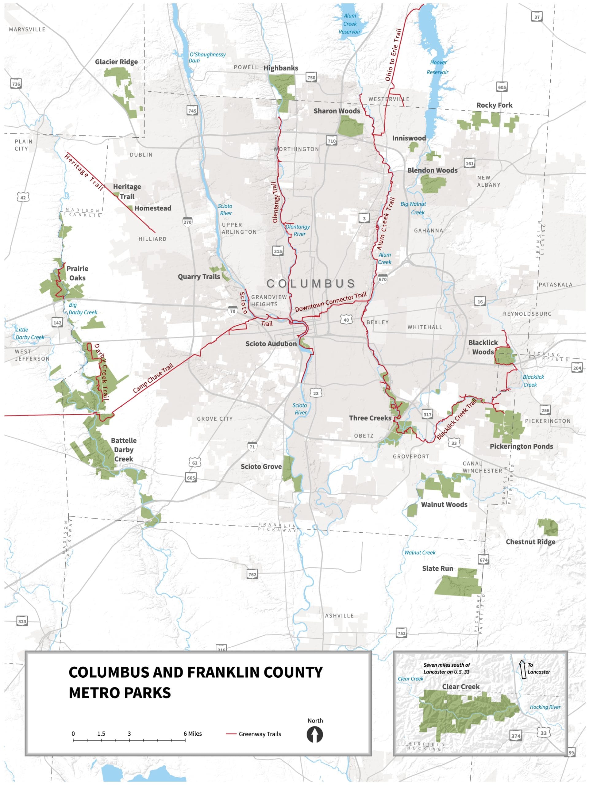
Columbus and Franklin County Metro Parks (Metro Parks) was established in 1945. It is a public agency serving the citizens of central Ohio by providing a regional system of parks. Metro Parks features 20 outstanding natural area parks with more than 230 miles of trails and over 28,700 acres of land in seven central Ohio counties.
www.metroparks.net
This blog describes the origin of the Columbus and Franklin County Metro Parks and provides an approximate location and description of the hiking trails available at each park. Some parks I have already done a blog for. Some parks I will do in the future.
Origins and Early Development
The idea for a metropolitan park system in Franklin County was proposed in a 1945 study, which highlighted the area's rivers and streams as ideal locations for parks, drawing inspiration from the Cleveland Metroparks system.
On Tuesday August 14, 1945, the park district was created in law by Franklin County Probate Court Judge Cloys P. McClelland, following a public hearing. This law was a state statute, passed in 1917, which provided for “the conservation of natural resources by the creation, development and improvement of park districts,” and which ultimately led to the visionary foresight of local citizens and environmental groups and the formation of plans for a park district in Columbus and Franklin County.
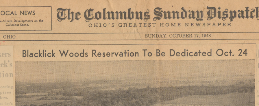
Walter A. Tucker, the first president-secretary of the Metro Parks, negotiated the purchase of the first land parcel in 1947, leading to the creation of Blacklick Woods Metro Park. This park was officially dedicated on October 24, 1948, and became a model for future parks in the system.
How is it Funded
The Metro Parks system operates as an independent political subdivision under Ohio Revised Code Section 1545. It is governed by a Board of Park Commissioners appointed by the Judge of the Probate Court of Franklin County. The primary funding source is a 10-year, 0.95 mill levy approved by Franklin County voters in 2018, which supports operations, improvements, and land acquisitions.
The 20th Metro Park, Quarry Trails, results from a promise made in the 2018 Levy that we would have a Metro Park or Greenway Trail within five miles of every Franklin County resident. Quarry Trails completes that objective, and about 350,000 Franklin County residents live within five miles of the park
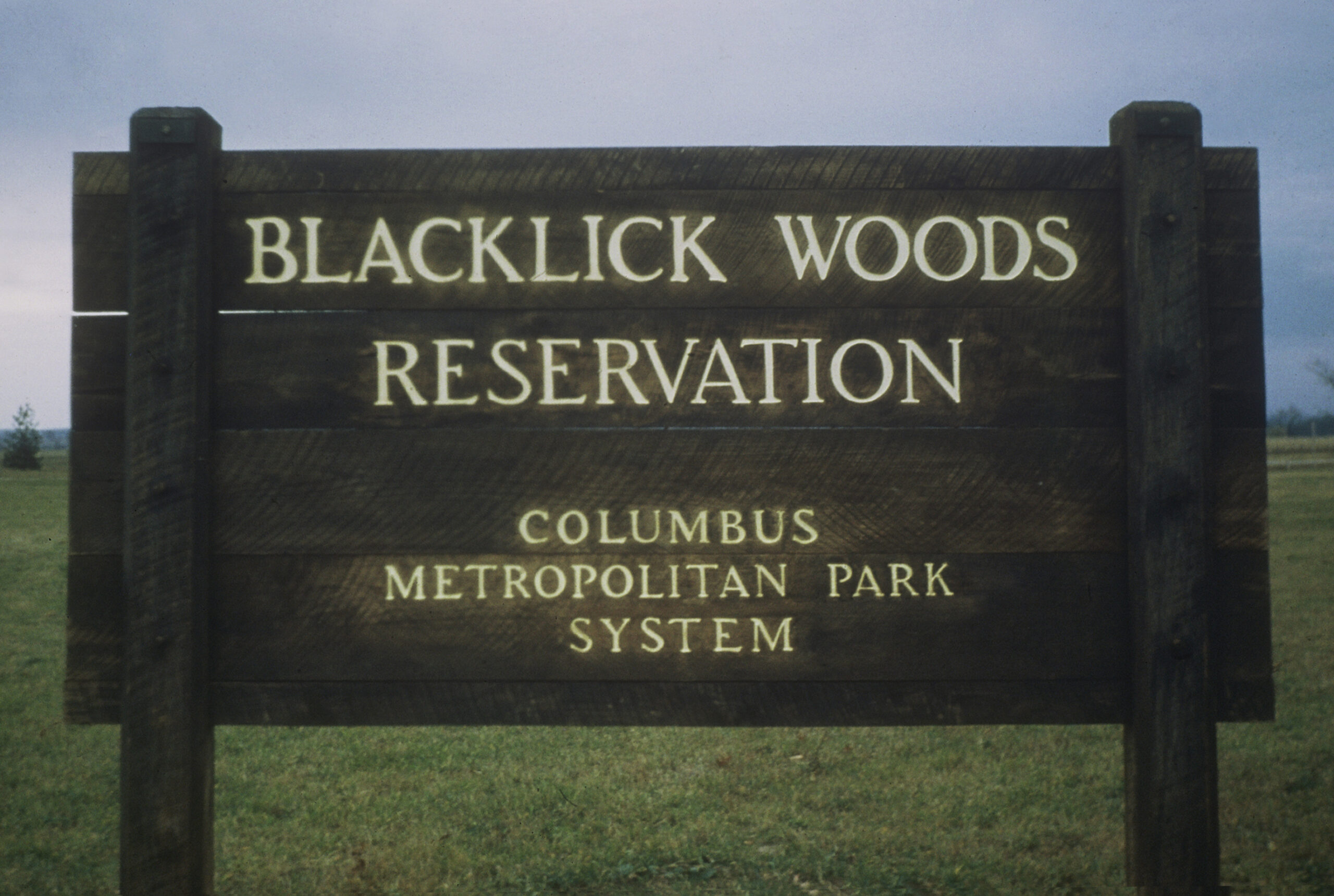
Note that in the early days, Metro Parks called its parks “reservations”, following the naming convention used by Cleveland Metroparks. By 1959, when Darby Creek opened, the familiar “Metro Park” became the regular name.
n 1971 the Metro Parks Headquarters relocated from East Broad Street in Columbus to its present location, the former Dunn house in Sharon Woods Metro Park.
List of Metro Parks Alphabetically:
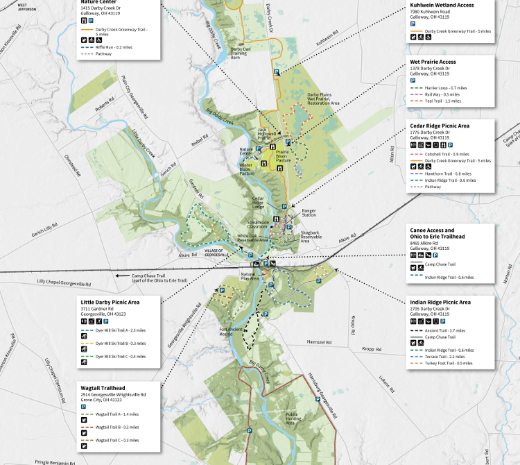
Battelle Darby Creek Metro Park
- Location: Galloway, OH
- Opened: 1959
- Highlights: Restored tallgrass prairie, American bison herd, nature center, Fort Ancient mound, 13 miles of creek trails. Much of the land was donated by the Battelle Memorial Institute. the largest Metro Park in Ohio, currently standing at 7,093 acres.

Hiking Trails
|
Ancient- |
|
1.7 miles |
|
Camp Chase |
|
12.5 miles |
|
Cobshell |
|
0.9 miles |
|
Darby Creek Greenway |
|
5 miles |
|
Dyer Mill |
|
3 miles |
|
Edgewood, Lake & Prairie Way |
|
2.3 miles |
|
Harrier Loop, Rail Way & Teal |
|
2.7 miles |
|
Hawthorn |
|
0.8 miles |
|
Indian Ridge |
|
0.6 miles |
|
Osprey Lake |
|
0.5 miles |
|
Riffle Run |
|
0.2 miles |
|
Terrace |
|
2.1 miles |
|
Turkey Foot |
|
0.5 miles |
|
Wagtail |
|
1.9 miles |
Note: Experienced backpackers can enjoy 10 miles of primitive backpacking trails along Big and Little Darby creeks. There are four overnight backpacking sites that are available by reservation only. For additional information and to make a reservation visit www.metroparks.net
Blacklick Woods Metro Park and Golf Course
- Location: Reynoldsburg, OH
- Opened: 1948
- Highlights: It is the oldest park in the system, Walter A. Tucker State Nature Preserve, certified Audubon golf course, birdwatching opportunities. In 1967, Stoney Creek Country Club, which ran a 126-acre golf course adjacent to Blacklick Woods, fell into financial trouble and offered its golf course for sale to Metro Parks. A well-run golf course was preferable to housing development, and that’s how Metro Parks entered the golf business.
- The Canopy Walk rises 40 feet into the air at Blacklick Woods, this wide boardwalk loops for an eighth-of-a-mile through the canopy of trees, including maples, beech, shagbark hickory and various oaks. An elevator provides easy access to the Canopy Walk, making it ADA accessible for wheelchair users.

|
Beech |
|
0.7 miles |
|
Blacklick Creek
Greenway |
|
16 miles |
|
Maple |
|
0.9 miles |
|
Buttonbush |
|
0.5 miles |
|
Multipurpose |
|
2.6 miles |
|
Walter A. Tucker |
|
0.1 miles |
Blendon Woods Metro Park
- Location: Northeast Columbus near Westerville, OH
- Opened: September 3, 1951
- Highlights: Rolling forested land, Walden Waterfowl Refuge, Thoreau Lake, nature center, disc golf course.
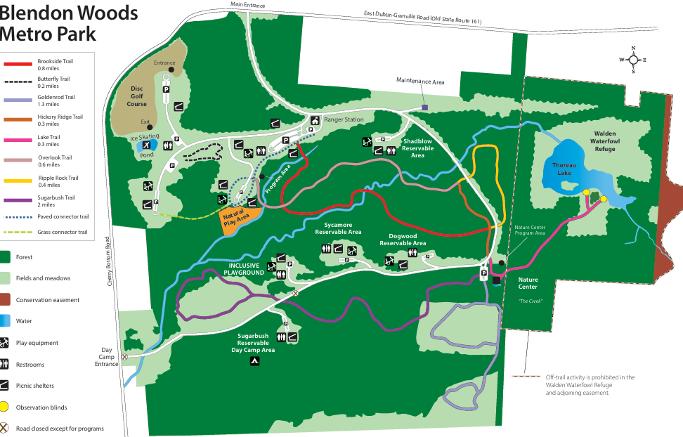
|
Brookside |
|
0.8 miles |
|
Goldenrod |
|
1.3 miles |
|
Hickory Ridge |
|
0.3 miles |
|
Lake |
|
0.3 miles |
|
Overlook |
|
0.6 miles |
|
Ripple Rock |
|
0.4 miles |
|
Sugarbush |
|
2 miles |
Chestnut Ridge Metro Park
- Location: Near Carroll, OH
- Opened: 1988-89
- Highlights: Overlooks with views of downtown Columbus, picnic areas, mountain biking trails.
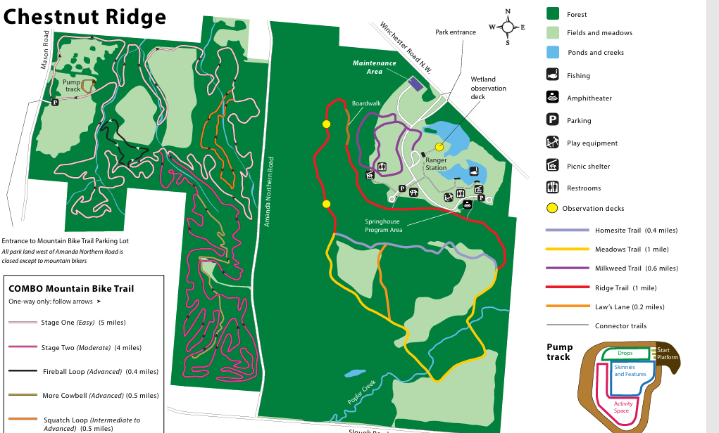
|
Homesite |
|
0.4 miles |
|
Meadows |
|
1 mile |
|
Milkweed |
|
0.6 miles |
|
Ridge |
|
1 mile |
|
Mountain Bike |
|
10.5 miles |
Clear Creek Metro Park
- Location: Near Rockbridge, OH
- Opened: 1996
- Highlights: A remote park with hemlock stands, deep hollows, wildflowers, designated State Nature Preserve.
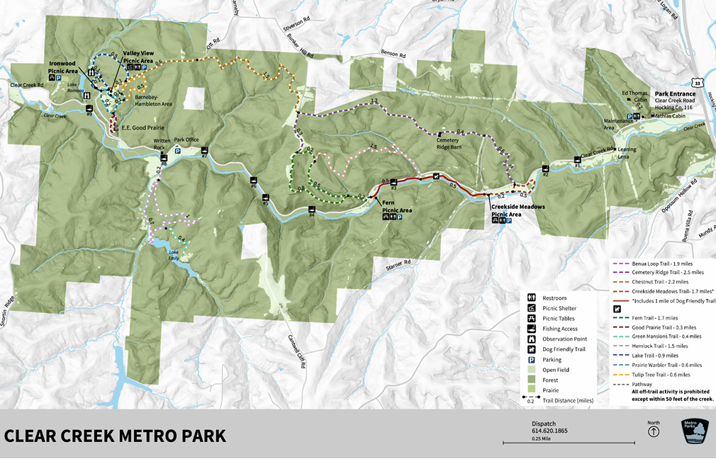
|
Benua |
|
1.9 miles |
|
Cemetery Ridge |
|
2.5 miles |
|
Chestnut |
|
2.2 miles |
|
Creekside Meadows |
|
1.7 miles |
|
Fern |
|
1.7 miles |
|
Good Prairie |
|
0.3 miles |
|
Hemlock |
|
1.5 miles |
|
Lake |
|
0.9 miles |
|
Prairie Warbler |
|
0.6 miles |
|
Tulip Tree |
|
0.6 miles |
Glacier Ridge Metro Park
- Location: Northwest of Dublin, OH
- Opened: 2002
- Highlights: Paved multi-use trail, disc golf course, bridle trail, large wetland area.
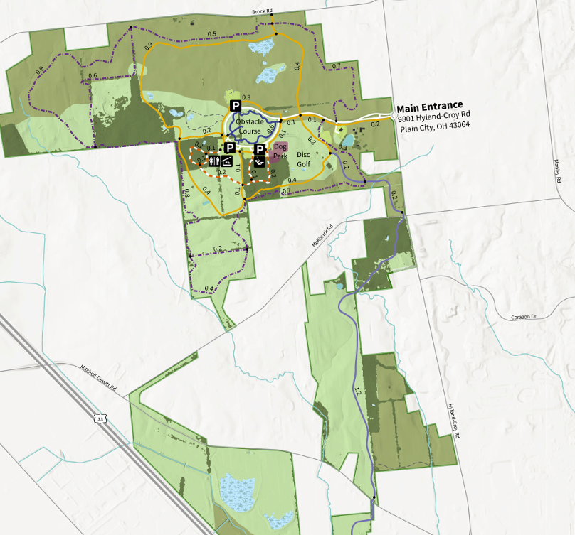
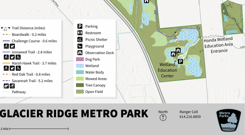
|
Ironweed |
|
2.8 miles |
|
Marsh Hawk |
|
2.3 miles |
|
Challenge Course |
|
0.5 miles |
|
Red Oak |
|
0.8 miles |
|
Savannah |
|
5 miles |
The 3-acre obstacle course features 12 challenging stations surrounded by a half-mile paved trail. Visitors can crawl through tunnels, climb poles and ropes and go over logs and more.
Heritage Trail Metro Park
- Location: Hilliard, OH
- Opened: 1995
- Highlights: 7-mile multi-use trail.
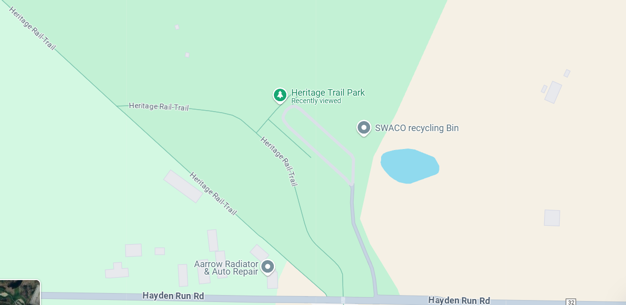
|
Multiuse |
|
6.1 miles |
|
Bridle |
|
3.6 miles |
Highbanks Metro Park
- Location: Lewis Center, OH
- Opened: 1973
- Highlights: Shale bluffs, nature center, sledding hill, Adena culture mounds, Edward F. Hutchins State Nature Preserve. Opened in 1973, it is known for its 100-foot shale bluffs and ancient earthworks. Designated as a National Natural Landmark in 1980, it offers trails, a nature center, and a sledding hill.

|
Big Meadows Path |
|
1 mile |
|
Coyote Run |
|
3.5 miles |
|
Dripping Rock |
|
2.5 miles |
|
Multi-Use |
|
2.3 miles |
|
Oak Coves Path |
|
0.4 miles |
|
Overlook |
|
2.3 miles |
|
Scenic River |
|
0.6 miles |
|
Sycamore |
|
0.9 miles |
|
Wetland Spur |
|
0.4 miles |
Homestead Metro Park
- Location: Hilliard, OH
- Opened: 2014-2016
- Highlights: Covered bridge, replica train station, outdoor amphitheater, paved trail connecting to Heritage Trail.

|
Multiuse Trail |
|
0.8 miles |
Innis wood Metro Gardens
- Location: Westerville, OH
- Opened: 1984
- Highlights: Managed botanical garden with theme gardens showcasing various plant communities is the 37-acre estate of sisters Grace and Mary Innis. Mary decided to gift the estate to Metro Parks in 1968, with the stipulation that she be allowed to live out her life in her home, and that the sisters’ beloved gardens and woodlands would be preserved for future generations to enjoy. Now a renowned 121-acre botanical gardens, Inniswood honored the memory of Grace and Mary by creating the 2.8-acre Sisters’ Garden in 2002. Their former home is now Innis House, which provides office space, a library and a meeting room for horticultural groups.
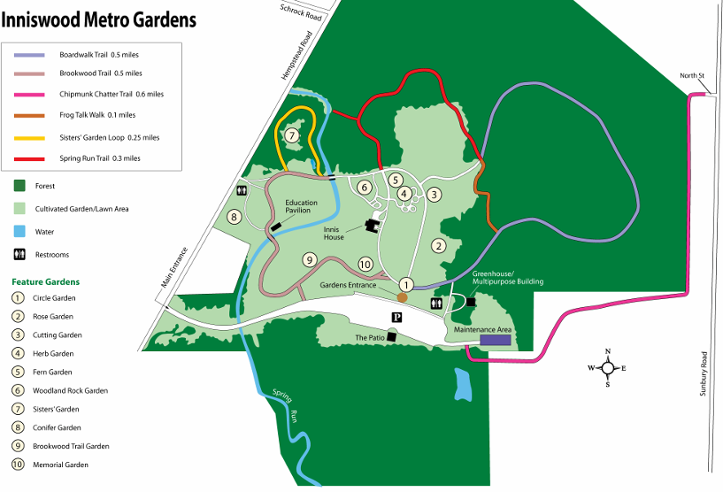
|
Boardwalk |
|
0.5 miles |
|
Brookwood |
|
0.5 miles |
|
Chipmunk Chatter |
|
0.6 miles |
|
Frog Talk Walk |
|
0.1 miles |
|
Sister’s Garden
Loop |
|
0.3 miles |
|
Spring Run |
|
0.3 miles |
Pickerington Ponds Metro Park
- Location: Canal Winchester, OH
- Opened: 1986-89
- Highlights: 1608 acres, several trails, 5 overlooks for bird and wildlife watching, designated Important Bird Area by Audubon Ohio.
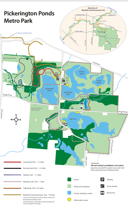
|
Arrowhead |
|
1.7 miles |
|
Blacklick Creek
Greenway |
|
16 miles |
|
Killdeer |
|
1.1 miles |
|
Meadowlark |
|
1 mile |
|
Yellowlegs |
|
0.5 miles |
|
Burning Lake |
|
1.5 miles |
Prairie Oaks Metro Park
- Location: Franklin and Madison County border, OH
- Opened: 2000
- Highlights: Restored Oak Savannah, former quarry area offering boating opportunities, canine swimming area.

|
Alder |
|
0.6 miles |
|
Beaver Lake |
|
0.9 miles |
|
Bridle |
|
5.7 miles |
|
Coneflower |
|
2.5 miles |
|
Darby Creek
Greenway |
|
3.5 miles |
|
Lakeview Trails |
|
0.9 miles |
|
River Rock |
|
0.7 miles |
|
Sycamore Plains
Trails |
|
2.2 miles |
Quarry Trails Metro Park
- Location: Columbus, OH
- Opened: November 30, 2021
- Highlights: Former limestone quarry, 25-foot waterfall, trails, boardwalks, zipline, rock climbing wall, historical significance. A rock-climbing wall utilizing stones from the former Marble Cliff Quarry opened in 2023.
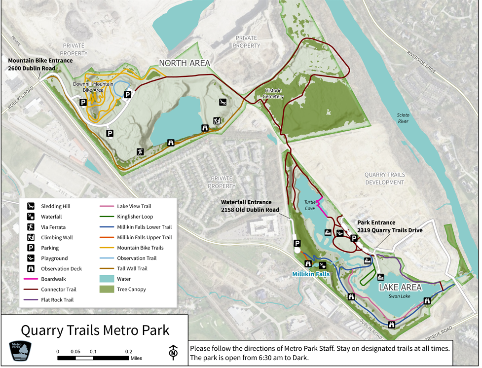
|
Boardwalk |
|
0.1 miles |
|
Connector Trails |
|
0.4 miles |
|
Flat Rocks Trail |
|
0.3 miles |
|
Lake View Trail |
|
0.3 miles |
|
Millikin Falls
Lower Trail |
|
0.8 miles |
|
Millikin Falls
Upper Trail |
|
0.05 miles |
|
Observation
Trail |
|
0.1 miles |
|
Tall Wall Trail |
|
0.8 miles |
Rocky Fork Metro Park
- Location: Westerville, OH
- Opened: 2014-2016
- Highlights: Woods and fields, bridle trail, dog park, off-leash dog trail, paved trail, nature trails, picnic shelter, wetlands.
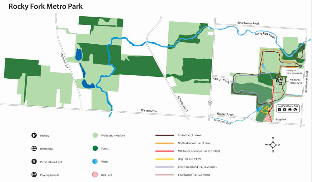
|
Beech Woodland |
|
1.3 miles |
|
Bridle |
|
3 miles |
|
Dog |
|
0.3 miles |
|
Millstone
Connector |
|
0.5 miles |
|
North Meadow |
|
1 mile |
|
Bevelhymer |
|
0.5 miles |
Scioto Audubon Metro Park
- Location: Brewery District, Downtown Columbus, OH
- Opened: 2008
- Highlights: Urban park, major bird migration stopover, Grange Insurance Audubon Center, climbing wall, old water tower with overlook deck.Active recreational features gave Scioto Audubon a slightly different feel to other parks, and include a 35-foot climbing wall, one of the largest outdoor climbing walls in the country, and a 10-stage obstacle course, built in partnership with the Columbus Rotary Club.
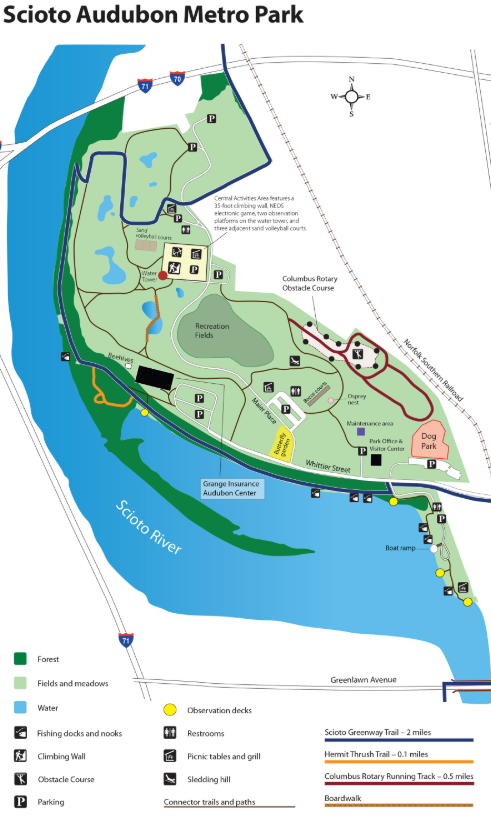
|
Scioto Greenway |
|
10 miles |
|
Connector |
|
2.5 miles |
|
Hermit Thrush |
|
0.1 miles |
Scioto Grove Metro Park
- Location: Grove City, OH
- Opened: 2016
- Highlights: Backpacking sites, trails through woods and along the river.
For additional information and to make a reservation visit www.metroparks.net

|
Arrowhead |
|
0.7 miles |
|
Connector |
|
0.2 miles |
|
Mingo |
|
2.5 miles |
|
Multipurpose |
|
2 miles |
|
Overlook |
|
1.2 miles |
|
REI River |
|
1.8 miles |
|
Ridge Top Course |
|
0.3 miles |
|
Woodland Course |
|
0.3 miles |
Sharon Woods Metro Park
- Location: Westerville, OH
- Opened: 1968
- Highlights: Sharon Lake, nature center, picnic areas, trails.
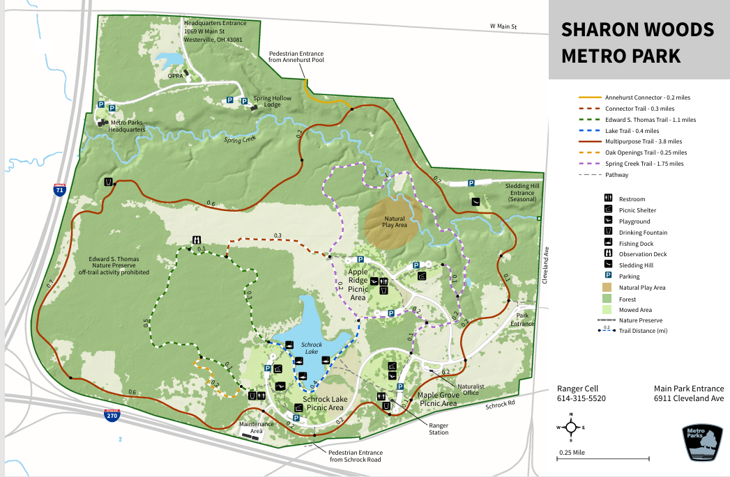
|
Edward S Thomas |
|
1.1 miles |
|
Spring Creek |
|
1.8 miles |
|
Multipurpose |
|
3.8 miles |
|
Lake |
|
0.4 miles |
|
Oak Openings |
|
0.2 miles |
|
Connector |
|
0.3 miles |
Slate Run Metro Park and Slate Run Farm
- Location: Canal Winchester, Ohio
- Opened: 1981
- Highlights: In the early 1960s, a 300-acre farmland in Pickaway County closed down. The farm had been cultivated continuously since 1805, and included a farmhouse, built in 1856, and a barn built in 1881. Metro Parks planners were eager to preserve the agricultural heritage of greater Columbus and purchased the site in 1964. It would take 17 years of restoration and hard work before the concept of a Living Historical Farm could be made a reality.
- The restored farmhouse and barn were added to the National Register of Historic Places in 1975, eight years before the Living Historical Farm was opened to the public.

|
Bobolink
Grassland |
|
1.5 miles |
|
Camp Starview |
|
1.7 miles |
|
Covered Bridge |
|
0.5 miles |
|
Five Oaks |
|
1.5 miles |
|
Kokomo |
|
1.5 miles |
|
Lake |
|
0.3 miles |
|
Sassafras |
|
2.1 miles |
|
Shagbark |
|
0.5 miles |
|
Sugar Maple |
|
1.3 miles |
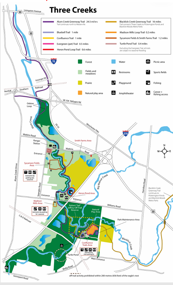
Three Creeks Metro Park
- Location: Columbus, OH
- Opened: 1998
- Highlights: Confluence of Big Walnut, Alum, and Blacklick Creeks, trails, fishing opportunities.
|
Alum Creek
Greenway |
|
|
24.5 miles |
|
|
Blacklick Creek
Greenway |
|
|
16 miles |
|
|
Bluebell |
|
|
1 mile |
|
|
Confluence |
|
|
1 mile |
|
|
Evergreen |
|
|
0.5 miles |
|
|
Heron Pond |
|
|
0.6 miles |
|
|
Madison Mills |
|
|
0.2 miles |
|
1.2 miles |
|
|
Turtle Pond |
|
|
0.4 miles |
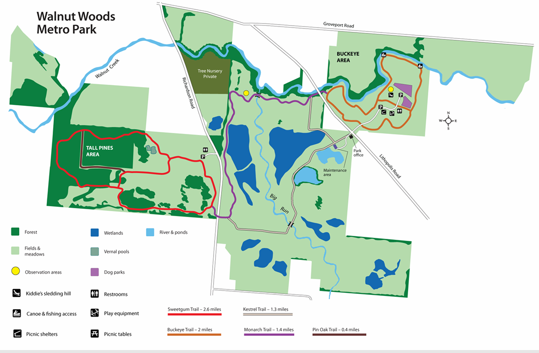
Walnut Woods
- Location: Reynoldsburg, OH
- Opened: 2011
- Highlights: features 1,458 acres of woodlands and fields, bordered by Walnut Creek to the north. The Tall Pines area features dramatic stands of pines and sweetgum trees, and the Buckeye area has long rows of old nursery trees such as serviceberry, crab apple and red maples. The park also features restored wetlands and vernal pools.
|
Buckeye |
|
2 miles |
|
Kestrel |
|
1.3 miles |
|
Monarch |
|
1.4 miles |
|
Pin Oak |
|
0.4 miles |
|
Sweetgum |
|
2.6 miles |
Opening soon
- Great Southern Metro Park: A 50-acre site offering water recreation and trail connections to nearby parks and downtown Columbus. Metro Parks also plans on opening another park in the southeast sector of Franklin County, formerly known as Hoover YMCA Park (Hoover Y-Park).
- Bank Run Metro Park: Located near Rickenbacker Airport, this park features a renovated lodge and event venue, with trails open to the public.
State Nature Preserves Associated with Metro Parks
Part of Clear Creek Metro Park, Allen F. Beck State Nature Preserve, which, at 4,729 acres, is the largest state nature preserve in Ohio. It is one of five state nature preserves within the park district. The other state nature preserves in Metro Parks are the 54-acre Walter A. Tucker State Nature Preserve at Blacklick Woods, the 206-acre Edward F. Hutchins State Nature Preserve in Highbanks Metro Park (named in honor of a former Director of Metro Parks), the 418-acre Pickerington Ponds (Metro Park) State Nature Preserve, and the 320-acre Edward S. Thomas State Nature Preserve in Sharon Woods Metro Park (named after one of the first Metro Parks board commissioners and a leading Ohio naturalist).
Conclusion
The Metro Parks system has a lot to offer. There are hiking trails at every park. No excuses, get out and enjoy the Metro Parks.