Charleston Falls Preserve: Ohio's Miniature Niagara Hike
They call it the Miniature Niagara, and I want to set your expectations honestly before you drive out there, because the nickname does some heavy lifting. Charleston Falls is a 37-foot waterfall in the rolling farm country of Miami County, north of Dayton. The "Niagara" part isn't about the volume — on a dry August afternoon it can thin out to what one local writer affectionately called the "Charleston Tinkle." The Niagara part is about the rock. The strata the water pours over here are the same geological layers that form the famous falls up on the New York–Ontario line. Same recipe, much smaller portion. And honestly? It's lovely, and the rest of the preserve around it is what makes the trip more than a one-photo stop.
Charleston Falls Preserve is the most-visited park in Miami County, and after one loop you understand why. It's 216 acres of forest, prairie, and limestone cliff, laced with close to four miles of well-built trail, all orbiting a waterfall that drops into a shaded grotto with a little cave behind it. It's a great family hike, an easy half-day, and a genuinely interesting piece of Ohio geology. Here's how to get the most out of it.
Trail Stats
- Distance: about 3.7 miles of trails total; the core Waterfall Loop is roughly 0.7 mile
- Difficulty: easy to moderate — short, with some stairs and rolling terrain
- Trail type: stacked loops (Waterfall Loop plus several connectors)
- Surface: packed dirt, wooden stairs, boardwalk, and observation decks
- Time: 1 to 2 hours depending on how many loops you add
- Where: Miami County, near Tipp City, north of Dayton
- Cost: free
Getting There
Charleston Falls sits between Tipp City and Springfield in southwest Ohio's Miami County, an easy run up from Dayton or down from the Springfield area. From Interstate 70 you're only a few minutes off the highway. The preserve is managed by the Miami County Park District — not Five Rivers MetroParks, which is the Montgomery County system one county south, an easy mix-up worth getting right when you're searching for directions.
The parking lot is free and decent-sized, but remember this is the most popular park in the county, so on a perfect-weather weekend it fills up. There's a restroom, a picnic area, and a trail map at the trailhead. Grab the map. The trail system is a tangle of short connectors with names like Redbud Valley and Thorny Badlands, and while you genuinely can't get lost on 216 acres, the map helps you string together exactly the loop you want.
For folks coming from Columbus, this is about an hour and fifteen out I-70 west — far enough to be a destination, close enough to pair with a Dayton-area day. Tipp City itself has a walkable, well-kept little downtown with places to eat, so it's an easy add-on after the hike, and the broader Dayton region is loaded with trails if you want to make a full day of it. I'll point you to a few of those at the end.
The Trail
Most people make a beeline for the waterfall, and that's the right instinct. From the parking lot, the Waterfall Loop heads out — go counterclockwise, turning right at the first junction and staying left to cut through a big open field, and it delivers you to the falls in well under a mile.
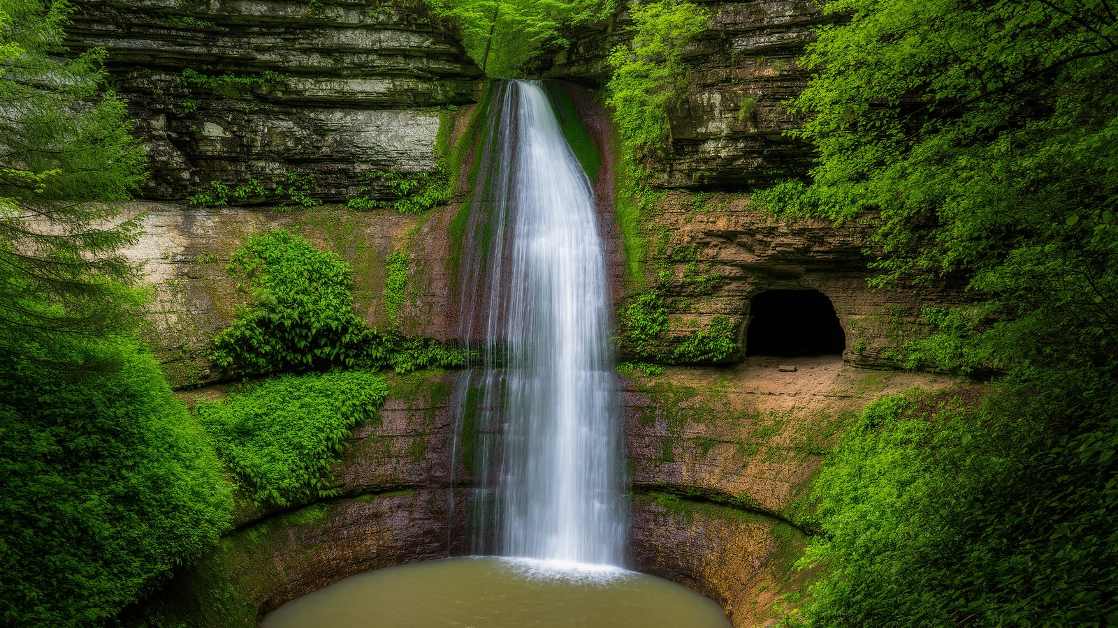
The approach is half the fun. You come through prairie and field, then the land tilts and you drop toward the sound of water. The falls themselves spill 37 feet over a rock face into a cool, shaded grotto. There's an observation deck positioned to take it in, and a set of wide wooden stairs and a boardwalk that let you get down close without tearing up the slope. Tucked behind and beside the falling water is a small cave — a recess in the rock that kids love and that gives the whole grotto a secret, sheltered feeling. On a hot day the air down there is noticeably cooler, the way it always is at the bottom of a damp Ohio ravine.
Here's the honest part again: the volume depends entirely on recent rain. The stream feeding the falls rises from small underground springs a few miles east and isn't a big flow to begin with. After a good rain or during spring snowmelt, the falls run full and photogenic. In a dry spell, it's a thin veil — pretty in its own delicate way, but not a roaring cataract. If the waterfall is your whole reason for going, check the weather and aim for the days after a soaking rain.
But don't make the waterfall the whole trip, because the surrounding loops are where the preserve earns its "most visited" title. Past the falls, the trail climbs and the terrain gets varied in a hurry. The Thorny Badlands trail runs through a stretch of scrubby, sun-baked ground — the name is earned, all locust and brambles and tough pioneer plants. Redbud Valley, as you'd guess, is a showcase in early spring when the redbuds light up the understory in magenta. There's a pine forest stretch that smells wonderful and goes quiet and dim under the needles. And there's Cedar Pond, a calm little pond you can circle, with benches set out for sitting and doing nothing, which is an underrated trail activity.
The whole network is unusually well-built. Bridges, wide wooden staircases, observation decks, boardwalks over the wet spots, and benches placed exactly where you want to sit and catch your breath or take in a view. You can feel that the park district has put real care into it over the years. It's the kind of trail design that makes a place welcoming to families, older hikers, and anyone who isn't trying to suffer for their nature.
History and Nature
The geology is the real story here, and it's worth slowing down for. That "Miniature Niagara" line isn't marketing fluff. The rock layers exposed at Charleston Falls are the same stratigraphic sequence — a hard, resistant dolomite limestone cap sitting over softer shale — that creates Niagara Falls hundreds of miles to the northeast. At both places, water pours over the hard cap rock and undercuts the soft layer beneath, slowly eating the falls backward upstream over geologic time. You're looking at the exact same waterfall-making process Niagara runs on, just at a scale you can take in with one glance. For anyone trying to teach a kid how waterfalls and gorges actually form, it's a perfect, comprehensible classroom.
The water that does the work originates from small underground springs several miles to the east, surfaces here, plunges the 37 feet, and then meanders west about a mile to join the Great Miami River. So the falls are one link in a longer water story, the place where groundwater briefly becomes spectacle before rejoining the river system that drains this whole part of Ohio.
The 216 acres wrap a surprising amount of habitat variety around that centerpiece. There's forested hill country, the prairie and field you cross on the way in, limestone cliffs, the grotto microclimate at the falls, and the pond. That patchwork supports a long list of wildflowers — Redbud Valley is named for its spring show, and the preserve is a known spot for spring blooms generally — plus the usual rewarding mix of birds and small wildlife you get wherever Ohio packs several habitats close together. The cliff and grotto stay cool and damp enough to host ferns and mosses that wouldn't survive out in the open field a few hundred yards away.
There's been a nature park here for decades, and Charleston Falls has long been the property people name first when they talk about the Miami County Park District. Longtime visitors will tell you it used to be a quiet local secret and has become genuinely popular, which is both a compliment to the place and a good reason to go on a weekday if you can swing it.
A Closer Look at the Habitats
What I appreciate most about Charleston Falls is how much variety the park district packed into 216 acres, and how legible it all is from the trail. You walk through four or five distinct little worlds in the space of an easy loop, and each one has a name that actually tells you what you're in.
Redbud Valley is the spring star. In late April the eastern redbuds throw out their magenta blossoms before their leaves even open, and a whole hillside of them in a sheltered valley is a genuinely beautiful thing. Redbuds are an understory tree — they live in the dappled edge between full forest and open ground — so the valley's structure is what makes the show possible.
The Thorny Badlands is the opposite mood: a dry, scrubby, sun-hammered stretch where the soil is thin and the plants are tough. Locust trees, brambles, and hardy pioneer species hold ground that wouldn't support the lush forest growing a few hundred yards away. It's a good lesson in how much Ohio's plant communities are dictated by soil and sun and water — change those a little, and the whole cast of characters changes with it.
The pine forest is a planted stand, dim and quiet and carpeted in needles, that smells like Christmas on a warm day. Cedar Pond is the calm-water counterpoint, a small pond with a loop around it and benches for sitting. And threaded through all of it are the forested hills and limestone cliffs that give the park its relief and its overlooks. Five habitats, four miles, one easy afternoon — it's a remarkably efficient little preserve.
Tips and Seasonal Notes
Chase the rain. The single biggest factor in your waterfall experience is recent precipitation. Go in the days after a good rain, or during spring snowmelt, for the fullest flow. Midsummer dry spells leave it thin.
Spring is the all-around winner. Full falls, the Redbud Valley bloom, wildflowers across the preserve, and comfortable temperatures. Fall brings color through the forested loops. Winter can be quietly spectacular when the falls partially freeze into ice columns — just mind the stairs, which get icy.
Go early on weekends. Most-visited park in the county means a full lot by midmorning on a nice Saturday. An early start gets you the grotto to yourself and a parking spot without hunting.
Mind the stairs and the kids. The wooden staircases down to the falls are sturdy but steep, and the rocks near the water are slick. It's very kid-friendly overall — short distances, a cave, a pond — but keep little ones close at the falls overlook and on the wet stone.
Footwear and water. Trail shoes are plenty; you don't need boots for this one. Bring water in summer — the open prairie sections get hot and exposed, even though the grotto is cool.
Build a loop. Don't just walk in to the falls and back out. Add the Thorny Badlands, swing past Cedar Pond, take the pine forest stretch. The extra mile or two is what turns a quick stop into a satisfying hike.
Nearby Trails
Charleston Falls makes a great anchor for a southwest-Ohio outing:
- The Ohio waterfall hikes roundup puts Charleston Falls alongside the other cascades worth chasing across the state.
- Planning around Dayton? The best hikes near Dayton guide rounds up the region's trails for a full day out.
- For another southwest-Ohio gorge with bigger water, Glen Helen Nature Preserve and neighboring John Bryan State Park are a short drive east near Yellow Springs.
Come for the Miniature Niagara, sure. But give yourself the extra hour to circle the badlands, sit by Cedar Pond, and walk the pine forest. Charleston Falls is the most popular hike in Miami County for reasons that go well beyond one 37-foot drop — and if you time it for a wet week, that drop lives up to its nickname too.
More in
Great Seal State Park: The Rugged Hills That Inspired the Ohio State Seal
Great Seal State Park near Chillicothe hides Ohio's most rugged ridge hiking. Climb Sugarloaf Mountain to the view that inspired the state seal.
Gahanna Woods State Nature Preserve: A Quiet Swamp Forest Loop
A guide to Gahanna Woods State Nature Preserve near Columbus, Ohio — spring vernal pools, buttonbush swamps, boardwalk trails, and rare wildflowers.
Leo Petroglyph and Nature Preserve: Ancient Carvings and a Gorge
Visit Leo Petroglyph and Nature Preserve in Jackson County, Ohio: 37 ancient Fort Ancient carvings and a short, rugged hemlock-gorge trail.